
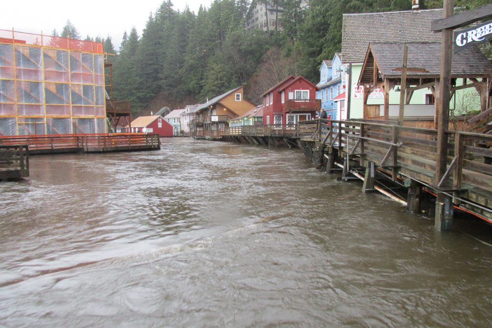
Creek Street is seen near high tide from the Stedman Street Bridge.
At a recent Ketchikan Chamber of Commerce luncheon, borough planner Richard Harney gave a presentation about the National Flood Insurance Program and new flood mapping. In a later interview with KRBD, Senator Bert Stedman offered his thoughts on the issue.
Harney gave the same presentation he had at a community forum in late January, but included a few updates. He began with an overview of FEMA’s National Flood Insurance Program and the history of the borough’s participation.
The current flood zone maps were drawn in the 1990s, and include just the City of Ketchikan. Updated maps will cover the entire Ketchikan Gateway Borough road system and creek floodplains. The number of affected properties will expand from 48 to about 1,100.
While it is voluntary for communities to participate in the program, Harney says there are consequences for opting out.
“If we get out. No resident will be able to purchase a flood insurance policy from FEMA through the NFIP program. That does not mean that their mortgage does not require flood insurance to be purchased. All it means that you can’t buy it from the NFIP. You can’t buy it subsidized. You still have to go and find it from somewhere else.”
In opting out, Harney also says existing flood insurance policies would not be renewed, and the community would not qualify for federal grants if a flood disaster happened.

A FEMA official talks to Ketchikan residents about new flood zone mapping that will include more properties than previously in areas considered at risk for flooding. (KRBD photo by Leila Kheiry)
Harney says in order to get insurance, elevation certificates are required. The certificates document, among other things, a property’s elevation above sea level, and where it is located in relation to special flood hazard areas. Harney says in Alaska, the certificates must be completed by engineers and surveyors. He says the cost is variable.
“The lowest I have seen is $500. What I’ve heard from engineers and surveyors is about $1,000 is the high end. But really, it depends on these factors. So if there are a lot of them needed, then the engineers may charge more. We don’t know how much they cost, and it’s on an individual basis.”
The results of the engineering survey determine whether or not flood insurance is required, and if so, how much a property owner will pay. Harney says the national average annual cost for flood insurance through NFIP is $672. He says for Ketchikan, the average cost is $2,014. Several commercial property owners attending the chamber lunch remarked that their premiums were much higher, one paying approximately $9,000 annually.
Harney gave a timeline for the project schedule. He says the appeal period ends May 2nd, but the City and Borough Joint Cooperative Relations Committee is drafting a letter requesting an extension of the comment period.
“We are asking that that 90-day appeal period be lengthened to a year, so that way we can study this a little bit ourselves. They took four years to get this data. They’re giving us 90-days to review it, and comment, and do our own engineering.”
Harney says the committee is also requesting that FEMA ground truth data, rather than rely on aerial surveys and contour maps. The committee’s recommendations will be brought before the city council and borough assembly for approval.
Harney encourages property owners to review the maps, and if they believe there is an error, contact the borough planning department for assistance on filing an appeal.
Sitka Senator Bert Stedman says if communities decide to opt out of the program, and therefore no longer qualify for federally-backed housing loans, the Legislature is looking at bringing the Alaska Housing Finance Corporation in as the lender for shorefront properties.
“We’re currently trying to find the line of demarcation between where that hook they have in us, as far as if you don’t belong to the FEMA flood program, we’re going to restrict the community’s ability to access federally-backed mortgages. Where exactly that lies, not only geographically, but where does it lie in federal law or federal regulations or somebody’s dream on their desk.”
Stedman says the negative impacts of adopting FEMA’s program far exceed the benefits. He says in Southeast, the greatest risk would result from a tidal wave, not flooding.
“FEMA is so restrictive. They don’t want structures on pilings. They don’t want rock fills. Frankly, they’re pretty blatant about it. They want the development off of the shorefront, and we are shorefront people. If you take the shorefront away from Southeast Alaska, we basically have nothing left.”
Stedman believes FEMA is using Alaska and other states to subsidize Gulf Coast flooding. He questions the accuracy of the maps, and is concerned about proposed premium increases.
“If we’re in a federal flood program, we should be rated for the exposure we have in Alaska and in our region of Alaska, not with what goes on in Florida, in Texas or in New Orleans if they build it under water, which they have. Why should the community of Ketchikan pay for that? We don’t build a dike and build our homes under water below the high tideline. We have more sense than that.”
Stedman says addressing the flood mapping issue is one of the top items in his office.
If the project follows the current timeline, the new maps and insurance requirements will go into effect in Spring 2019.


