
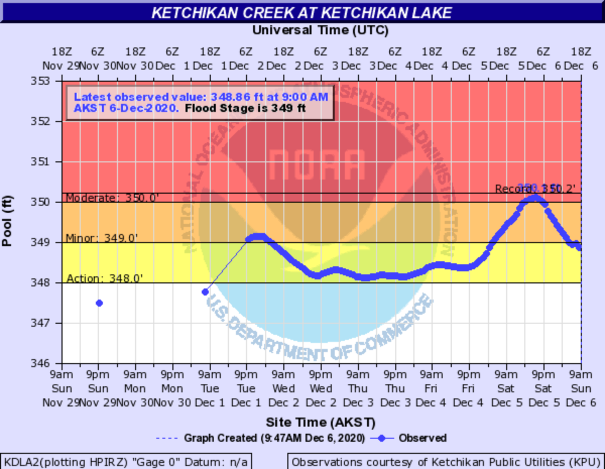
As of 9 a.m., the water level at Ketchikan Lake Dam was below 349 feet. (National Weather Service)
Final story: 1 p.m. Sunday, Dec. 6:
Water levels at the Lower Ketchikan Lake Dam have fallen enough that officials no longer anticipate a risk of dam failure. Officials said Sunday morning that residents who evacuated low-lying areas near Ketchikan Creek over the weekend can now return to their homes.
That’s after the dam reached near-record levels Saturday evening.
It was the wettest week in a century in Ketchikan. And that’s saying something — Ketchikan is already among the wettest cities in the U.S.
Alaska climate researchers say nearly 20 inches of rain fell on the Southeast Alaska city between Nov. 29 and Dec. 5. Expand that to an eight-day window, and it’s almost two feet of rain.
Ketchikan with 5.5" of rain in a 24-hour period. In the last 8 days, they have had 22.48" (through 8 p.m.). This is the 3rd largest 8-day total (non-overlapping days) for the wettest city (>5,000 people) in the U.S., and the most in 100 years (1917 & 1920). @AlaskaWx https://t.co/EmOjbqJwo1
— Brian Brettschneider (@Climatologist49) December 6, 2020
All that water pushed a reservoir upstream of town to near-record levels — just over an inch shy of the all-time record set in 2015. And that concerned local officials enough to recommend that people living near the creek get to higher ground.
“So we have two areas that we’re concerned about. One is the actual dam. But more importantly, is the low lying places along the creek,” Ketchikan Public Utilities Electric Division Manager Andy Donato said Saturday evening. His agency maintains the Lower Ketchikan Lake Dam.
Three feet of water were flowing from an ungated emergency spillway. Ketchikan Creek was ripping through town. The alert went out: parts of downtown and areas near the creek were told to evacuate. Officials stood up a shelter at the borough-owned rec center.
Donato said he feared accumulating debris could flood low-lying areas.
“It doesn’t take much to start plugging that up. And then and then we can see flood conditions develop rapidly. So that’s our first concern,” Donato said Saturday.
But the larger concern was a possible dam failure. Ketchikan Emergency Manager Abner Hoage said that would mean widespread devastation.
“In a dam break scenario, which is the worst case scenario, that would be a 22,000 cubic-foot-per-second release. We have 115 residential structures, 43 commercial structures and seven government structures,” he said.
Officials warned that lake levels of 351 feet could damage the dam. Three feet higher, at 354 feet, and water would spill over the earthen top of the structure.
But as of noon Sunday, officials said it likely won’t get to that point anytime soon. Heavy rains have let up slightly. Utility crews ran the dam’s hydroelectric generators overnight to let water out from behind the structure. And the lake level crested at 350.1 feet shortly after 7 p.m. Saturday.
Officials lifted the voluntary evacuation Sunday morning. While they warned of minor street flooding, they said there was no immediate danger of dam failure.
But they said they’re standing by — and they say residents should stay alert, too.
To sign up for local emergency alerts, text 99901 to 888777.
Original story and updates below.
UPDATE, 10:15 a.m. Sunday, December 6:
Water levels at the Ketchikan Lake Dam have fallen enough that officials no longer anticipate a risk of dam failure. Officials said Sunday morning that residents who evacuated low-lying areas near Ketchikan Creek can now return to their homes.
Utility crews ran the dam’s hydroelectric generators overnight in an effort to reduce the lake level, officials say. Forecasters expect about 1.5 inches of rain Sunday, but the lake is not expected to rise to critical levels in the near future.
As of 9 a.m., Ketchikan Lake is just below 349 feet and falling. That’s more than two feet below the threshold officials warned could threaten the dam’s integrity.
An emergency shelter at the Gateway Recreation Center will remain on standby for now, but officials say it’s no longer taking new arrivals. The Rec Center is scheduled to reopen to the public Monday morning.
Staff members will call residents that boarded pets at Ketchikan’s animal shelter to arrange for pickup.
Water levels at Ketchikan Lake peaked at 350.1 feet at 7 p.m. Saturday, according to the National Weather Service. That’s just over an inch shy of the all-time record of 350.2 feet set in 2015.
Localized flooding could still happen downstream of the dam, officials say. Freeman Street remains closed. A National Weather Service flood advisory for areas near Ketchikan Creek is scheduled to expire at midnight Sunday evening. Officials ask residents to stay alert and listen for updates.
UPDATE, 10:30 p.m. Saturday, December 5:
Officials continue to recommend that residents of low-lying areas near Ketchikan Creek evacuate to higher ground. They say the danger of flooding has not yet passed even as rainfall tapers off and the water level at Ketchikan Lake Dam begins to recede.
But Ketchikan’s emergency operations center says it does not anticipate forcing anyone to leave flood-prone areas — yet.
Officials had previously predicted a mandatory evacuation overnight.
“I think our immediate danger from the potential to get to that critical level up at the dam has probably passed for the night,” Ketchikan’s emergency manager, Abner Hoage said late Saturday night.
“I would sleep with my ringer on. I would not put my earplugs in if I normally sleep with earplugs — just so that you can remain somewhat alert,” he told KRBD.
But Hoage said rain is expected to pick up on Sunday.
“Probably another two inches between 6 a.m. and 3 p.m. So we’re going to be back back up to the level we’re at now, if not even above that, before we get through the worst of the weather tomorrow,” he said.
Officials would use audible sirens to indicate a mandatory evacuation, and police officers would patrol with loudspeakers, local officials say. There would also be a mobile phone alert via the Nixle notification system.
Hoage says residents who have already evacuated should not return to their homes.
[See a map with the areas under evacuation, information about shelter, and more here]
Hoage said at 10:45 p.m. Saturday the water level at Ketchikan Lake Dam has dropped slightly in the past few hours. As of 10 p.m., the lake was below 350 feet and falling.
For context, officials warn that levels about 351 feet could damage the dam. Levels above 354 feet could lead to more serious damage and threaten failure.
“By doing what we call the voluntary evacuation, it raises people’s attention. And it gives them more time to respond,” Hoage said. He said a mandatory evacuation would be issued if there was a more imminent threat.
Here’s a reminder of the areas recommended to evacuate:
All residents and businesses along Park Avenue, Harris Street, Freeman Street, Totem Drive, Nickey Way, Totem Way, Herring Way, Salmon Row, Woodland Avenue, Deermount Street (above Woodland Ave), Creek Street, and areas East of Bawden Street (on Dock Street, Mission Street and Mill Street). Local officials say the downtown Mary Frances apartment complex is not considered at risk.
Additionally, properties on Venetia Avenue and Peterson Street are recommended to evacuate. That’s because flooding along Park Avenue could leave those residents without a way out.
An evacuation shelter is set up at Ketchikan’s Gateway Recreation Center at 601 Schoenbar Road for those with nowhere else to go. But officials ask that residents first seek shelter with friends and family outside the evacuation zone.
Local officials say there’s only one road closure for now. That’s Freeman Street. Other roads are open to through traffic, including Stedman Street at the mouth of Ketchikan Creek. That’s the primary road connection between northern and southern parts of Ketchikan’s road system.
ORIGINAL STORY, 8 p.m. Saturday, Dec. 5:
Officials say they’re on the cusp of issuing a mandatory evacuation order for residents in low-lying areas along Ketchikan Creek. First responders are going door-to-door asking Ketchikan residents in these areas to pack a bag and be prepared to be displaced for two to three days.
Ketchikan Public Utilities Electric Division Manager Andy Donato says the danger of an uncontrolled dam release is very real.
As of 7 p.m. Saturday officials confirmed a mandatory evacuation order would be issued in the next few hours.
“I’m going to say 100% probable,” Donato said.
That’s as Ketchikan Lake Dam reached “moderate flood stage” Wednesday. Officials said in a statement that “conditions are developing that could cause a breach and failure of the Ketchikan Lakes dam by 3:00 a.m. Sunday morning.”
Emergency Manager Abner Hoage tells KRBD in a phone interview there’s not an imminent risk of the dam failing as of 7 p.m. Saturday.
But officials say that as the lake approaches record levels, they’re advising people to prepare for the worst.
“So we have two areas that we’re concerned about. One is the actual dam. But more importantly, is the low lying places along the creek,” Donato said. His agency maintains the Ketchikan Lakes Dam upstream from downtown.
Right now, officials are most concerned about flooding along Ketchikan Creek. Areas along the creek have been asked to evacuate.
[See the full list of evacuations, a map and shelter information here]
Donato says he’s concerned that flood-driven debris, like downed trees, could pile up under bridges or in narrow sections of the creek.
“It doesn’t take much to start plugging that up. And then and then we can see flood conditions develop rapidly. So that’s our first concern,” he said.
Ketchikan: the rec center is the emergency shelter if your home is flooding. Right now I’m told that is voluntary but could become mandatory soon with more rain. Stay safe friends pic.twitter.com/yErgHJsaoV
— Cheyenne Mathews (@CheyMathews) December 6, 2020
But the longer-term concern is the integrity of the dam. Donato says that water is expected to rise above a reinforced section of the dam by 3 a.m. Sunday morning, and that could lead to erosion. That would be at a lake elevation of 351 feet.
“At 351.0, structurally, we come up to something different in the interior of the dam, the dam that’s up there is an earthen dam, built on some old wooden cribs, and we start exceeding the internal cribbing,” Donato said.
The National Weather Service reported that the level was roughly 13 inches below that mark at 6 p.m. Saturday.
High lake levels are one of a few factors that could trigger a mandatory evacuation for low-lying areas near the creek. Hoage, the emergency manager, said that included a total of 28 residences and 25 commercial buildings.
Damage to the dam could also prompt mandatory evacuations.
Donato says he’s not quite sure when residents will be ordered to leave, but he anticipates evacuations being called this evening. He says plans are in flux as conditions on the ground change. But he says he’s sure an order will be issued Saturday.
Officials say they’ll activate audible sirens when a mandatory evacuation is issued. Police officers will also patrol with loudspeakers.
One reason an evacuation could be called earlier is the simple fact that it’s easier to get people to leave before they head to bed, Donato said.
Another major milestone would be reached at 354 feet, Donato said. That’s the height of the dam. And if water starts flowing uncontrolled over the top of the dam, that could lead to erosion, allowing larger and larger flows out of the dam, and potentially a dam failure.
Hoage says that could be devastating.
“In a dam break scenario, which is the worst case scenario, that would be a 22,000 cubic-foot-per-second release. We have 115 residential structures, 43 commercial structures and seven government structures,” he said.
Hoage says those in the evacuation zone should get to higher ground immediately.
“If it does get there, and if things were to go bad, and we were to have some sort of erosion or, you know, dam couldn’t hold that the weight of the water because you’re adding exponentially more water, the higher up it gets in that reservoir,” he said. “Then you get a crack, or whatever — an earthquake hits at the wrong time — and the water comes through for whatever reason.”
“That’s what we’re worried about the potential for,” he said.
The weather service expects another half inch overnight. Forecasters say they’re expecting another 2 inches during daylight hours Sunday and another half inch Sunday night. Rain is forecast to let up slightly by Monday with 0.75 inches expected.


