
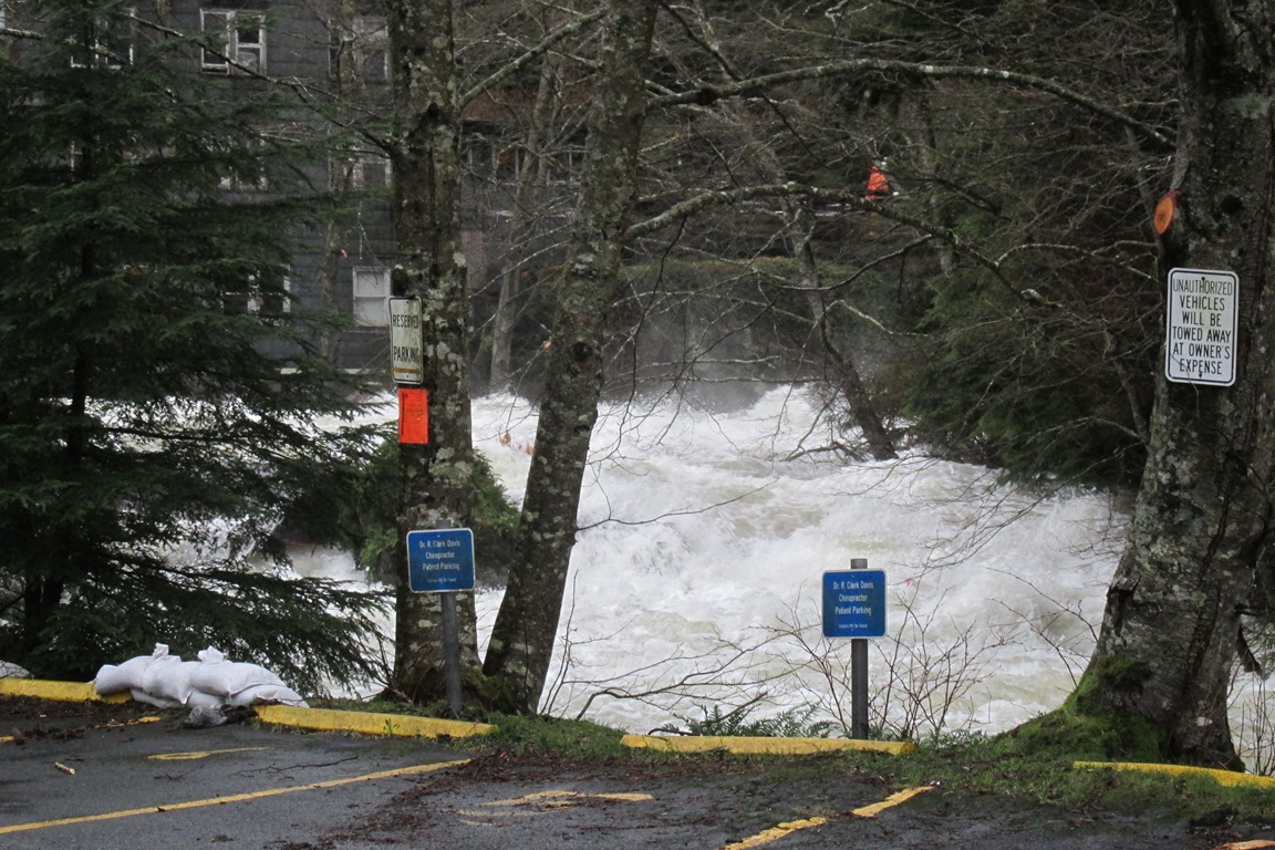
2023 was an especially wet year in Ketchikan. The First City was drenched in over 176 inches of rain last year. It was also a year for above average temperatures and rainfall across the Alaska Panhandle. KRBD’s Jack Darrell spoke with Alaska Climate Specialist Rick Thoman with the Alaska Center for Climate Assessments and Policy to find out why and what it could mean for the future.
Hey Rick.
So. Wettest year since 2005?
Yep.
You’re getting a nice baptism by rain there in Ketchikan-land.
I am. Yeah. But I guess with that in mind, why are we seeing this?
This was a feature of Southeast in 2023. Everybody had above normal precipitation. I haven’t found anybody that had their wettest year on record, but some places came close.
Sitka, I think, was fourth wettest. Juneau was top 10. Haines was a top 10 as well. So, maybe an interesting part is that in some ways, 2023 in Ketchikan was very much what we potentially think the future will look like. During the late spring and early summer, precipitation was actually below normal in Ketchikan. That wasn’t the case everywhere in Southeast but for southern Southeast, it was a drier than normal April to July period. And then the rains, of course, started up. This is actually something that we see in some of the climate projections. Total precipitation in southern Southeast for the year on an annual basis goes up. So, in that sense, this year comports very closely with what is a definite possibility for the future. More precipitation overall, but less rain in summer is exactly what we got.
Gotcha. So, this isn’t the work of the often talked about El Niño weather event then?
Well, that idea – the idea of more precipitation but drier summers – that would be climate change. A long-term, multi-decade outcome. The current fall weather is very consistent with past El Niño’s for Southeast Alaska. Not every El Niño, but there have been El Niño’s like this – when it’s just persistently warmer than normal and frequent rain rather than a couple of big storms.
That certainly was a contributor to the Wrangell landslide. Even that event, I mean, yeah, Wrangell got three inches of rain in one day but Wrangell gets three inches of rain in one day. Certainly, the very wet fall that preceded it played a role in that as well. So, I would say you were safe to attribute some of this fall weather to El Niño. I’ve seen this before – and farther west, back in your old stomping grounds, in Bristol Bay-land, coldest December since 2012. And that’s, again, all part of the same weather pattern.
Wow. Yeah. And the 29th of December here was the warmest 29th of December on record.
Yeah, yeah. It did set a write a daily record high.
How does that work? How it is unseasonably warm in Ketchikan and unseasonably cold in Bristol Bay?
The easiest way to think of it is during El Niño, storms preferentially track from the North Pacific into the Gulf of Alaska. And so, if a storm is taking that track, then Southeast Alaska is far enough east that you’re on the southerly wind side. Think of that counterclockwise rotation around low-pressure systems. If the storm is tracking through the middle of the Gulf of Alaska from, say, south to north, then Southeast Alaska will be on that warm southerly flow side. And what’s been maybe a little bit unusual with this El Niño – especially in December. The persistence of that.
Looking forward into the future. What might this mean? These drier summers and more rain in the winters – coming out of a year when we had some tragic landslides. Is this something to expect more of?
Yeah, that is a very interesting question. For the drier summers, of course, going along with that are warmer temperatures. That means that you got less rain. Warmer temperatures mean more evaporation from the ground. You get those warm, dry summer months. And that can really heat up rivers. Salmon don’t like to come into those warm waters. There are various insects in the Tongass – they’re not new, but they only thrive in warm, dry summers. And so, you get things like – I think there’s a type of budworm – and you get that budworm kill. So, all of that could be going on even as the precipitation for the year is going up. And if you have less rain in the summer, but more rain for the year, that means you have to be getting more rain in the non-summer time of year. And so, these extreme events – like in Wrangell, like in Haines and 2020, like in Sitka in 2016 – that’s going to continue to occur.
Hm.
I would just note that, Southeast Alaska has evolved – the landscape, the plants, everything has evolved to take a lot of water. You know, Southeast Alaska is one of the wettest areas at sea level – outside of the tropics – in the world. So, the environment is well adapted to a lot of rain. How will it change in response to a warmer environment? Potentially larger swings in precipitation? It remains to be seen. Historically, the early summer is the dry season in Southeast Alaska, although especially for southern Southeast, it’s still wet by almost all standards, right?
Thanks, Rick.
You bet. Stay dry.
CORRECTION: A previous version of this story stated 2023 was the sixth wettest year on record in Ketchikan. It should have said that it was the sixth wettest year on record since 2005. It was the 11th wettest year on record more generally.


